Hiking the French Alps with Kids: Saint-Gervais & Megève Trails
Alpine meadows carpeted in wildflowers, mountain lakes you earn through honest effort, and drone views that make the world look like a scale model. Here's what family hiking in the French Alps actually looks like.


There's a particular satisfaction in watching children discover that their legs can carry them to places most adults never bother reaching. In the French Alps around Saint-Gervais-les-Bains and Megève, the trails are demanding enough to feel like real adventures but rewarding enough that the complaints stop the moment the view opens up.
We spent several days hiking the highlands around Chamonix's less famous neighbours — the green valleys above Saint-Gervais, the sweeping ridgelines near the Col de Joly, and the forested slopes above Lac d'Annecy. The children, aged 9 and 13 at the time, handled every one of them with a resilience that surprised even us. And the drone came along for the ride, capturing scenes that no hiking photo can match.
Bookings: Some of the links in this article are affiliate links. This means that if you choose to make a booking, we will receive a small commission at no extra cost to you. Thank You!
Saint-Gervais Highlands: Alpine Lakes and Green Valleys
The area above Saint-Gervais-les-Bains, on the western flank of the Mont-Blanc massif, is hiking territory at its finest — less crowded than the Chamonix valley, greener, and with a sense of openness that the narrow Chamonix corridor can't match. If you'd like to join a guided hike with a professional mountain guide, several operators base themselves here.
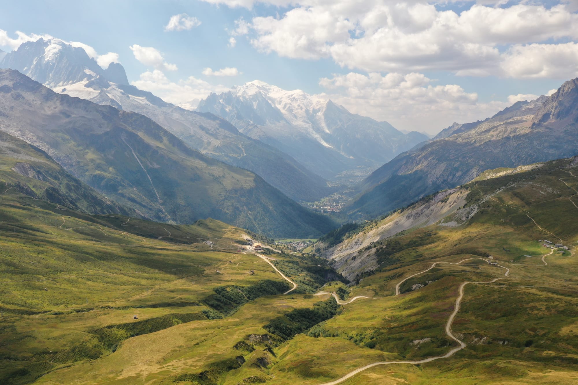
Our hike climbed to around 2,250 metres, passing through alpine meadows to reach a stunning turquoise mountain lake nestled between grassy slopes. The water was cold enough to make wading a brief affair, but the setting — mountains reflected in the still surface, silence except for the distant jangle of cowbells — was the kind of moment that stays with you.
The real visual revelation came when the drone went up. From 2,100 metres, the footage revealed the full extent of the valley below — a vast green amphitheatre carved by glaciers, with hiking trails winding like white threads through the meadows and the Mont-Blanc massif rising in the distance, its glaciers gleaming even under midday light.
Wildflower Trails and Mont-Blanc Views
The descent from the lake took us along a ridge trail lined with pink-purple fireweed (épilobe) in full August bloom. The flowers created a foreground carpet of colour against the deep valley and the snow-capped Mont-Blanc beyond — one of those scenes that no amount of planning could produce. You just have to be there at the right time.
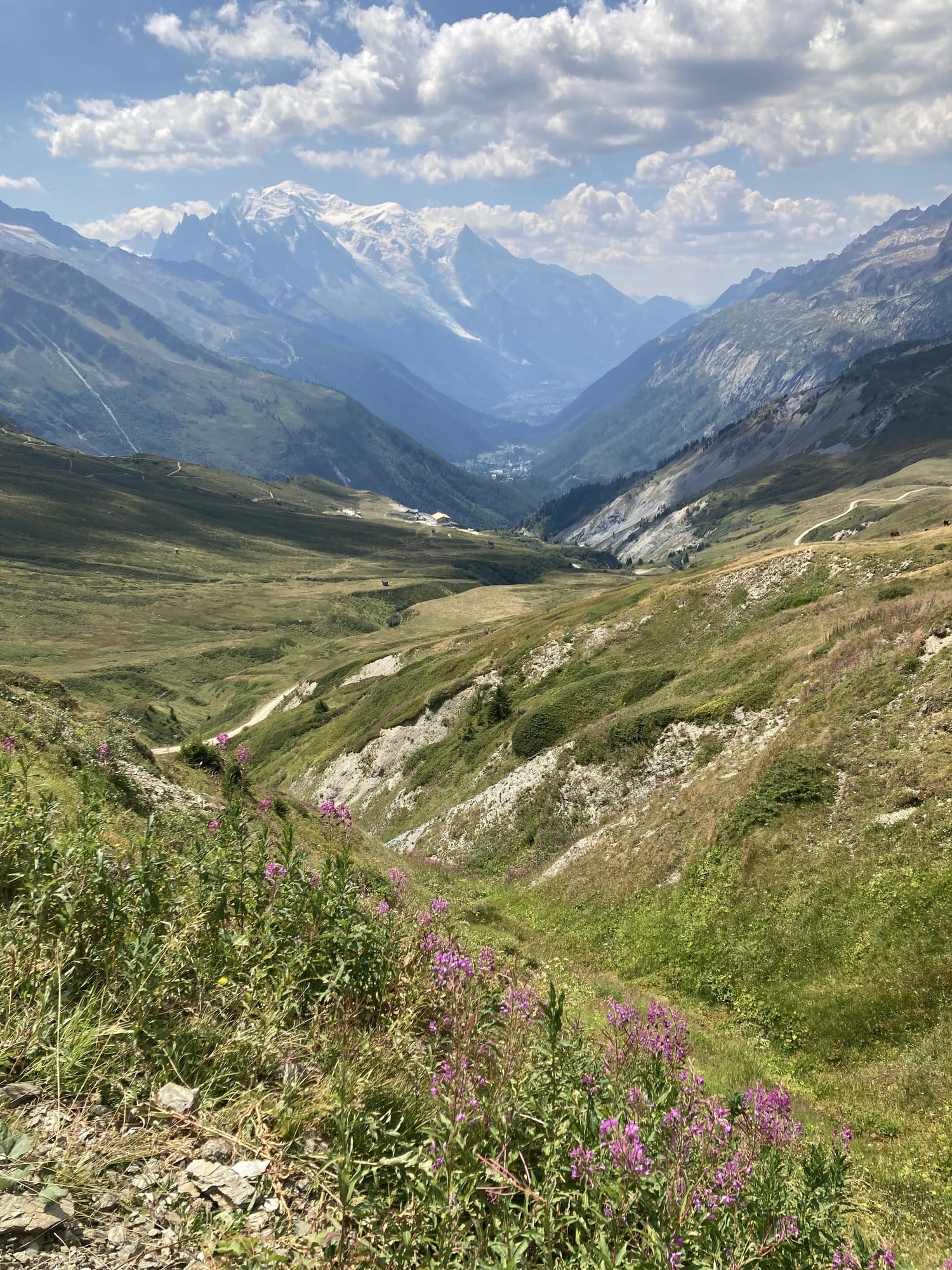
The trail continued through rolling alpine terrain, with the Mont-Blanc views evolving constantly. Each turn of the path offered a slightly different composition — more glacier here, more shadow there, always the same impossibly white summit dominating the horizon.
Drone Views: Five Flights Above the Alps
This was the day we made the most of the drone, launching five separate flights from various points along the hike. The aerial perspectives transformed familiar mountain scenery into something almost abstract — the scale of the valleys, the patterns of the trails, the way the light fell on different slopes.
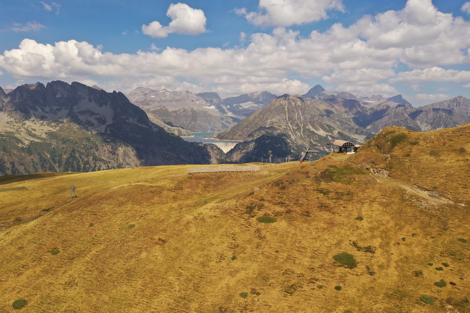
One flight captured a lone mountain refuge perched on a hillside, with a reservoir lake visible in the distance — the kind of scene that makes you realize how much wilderness still exists just hours from major cities.
Megève Area: Ridge Walks at 2,400 Metres
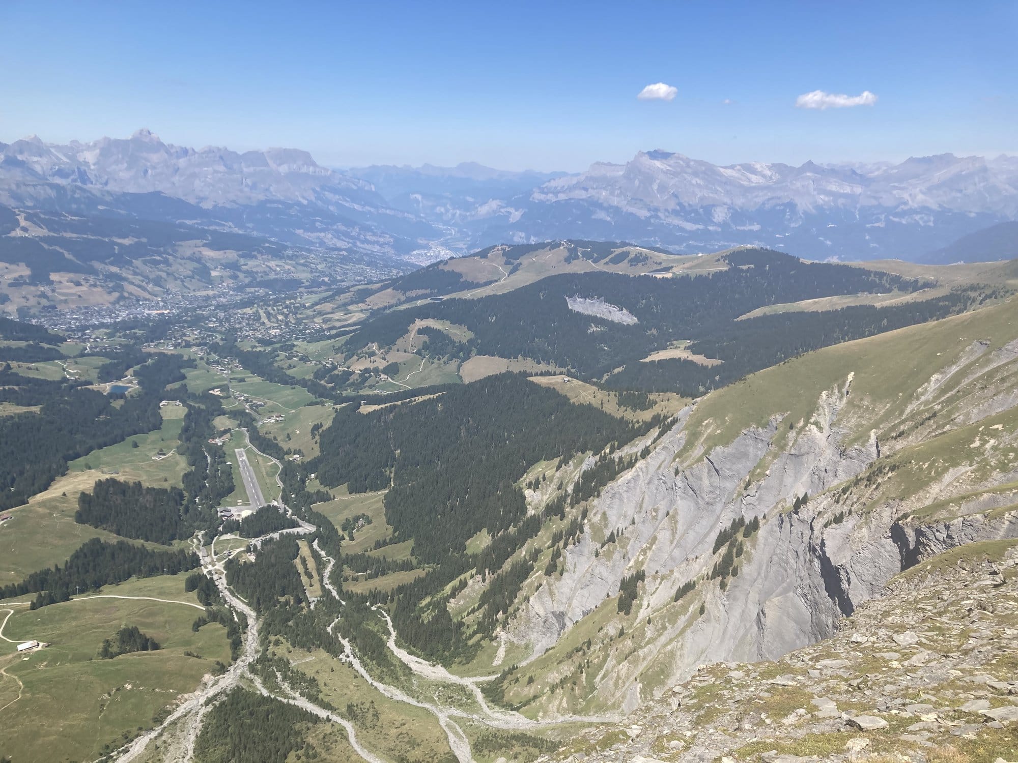
A few days later, we tackled a more ambitious hike in the highlands above Megève, reaching ridgelines at nearly 2,420 metres. The terrain here is different from the Chamonix side — broader, more open, with wide alpine grasslands that turn golden in late August.
The trail followed a series of ridges with constantly changing views. On one side, the green valleys and villages around Megève spread out like a map. On the other, distant peaks — including the unmistakable profile of Mont-Blanc — lined the horizon.
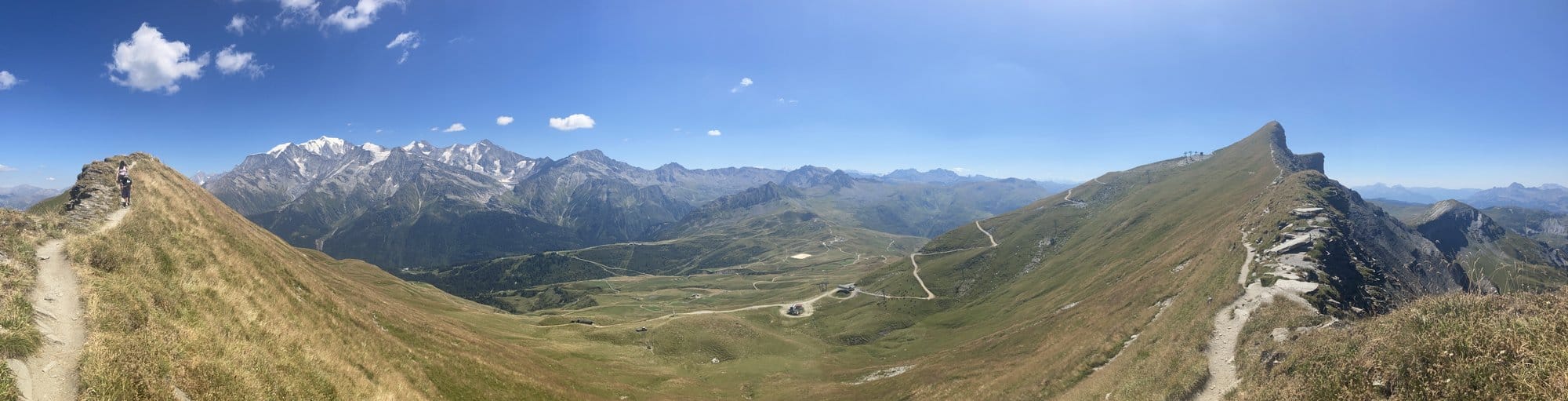
The 360° Panorama at the Col
The highlight was reaching a col at around 2,384 metres, where the trail opens into a full 360-degree panorama. To the left, the Mont-Blanc massif anchored the view with its glaciers and snow. Straight ahead, green alpine grasslands rolled away toward distant ridges. To the right, a sharp pyramidal summit — most likely the Aiguille Croche — cut against the blue sky. Trails snaked across the ridgelines in both directions, inviting exploration.
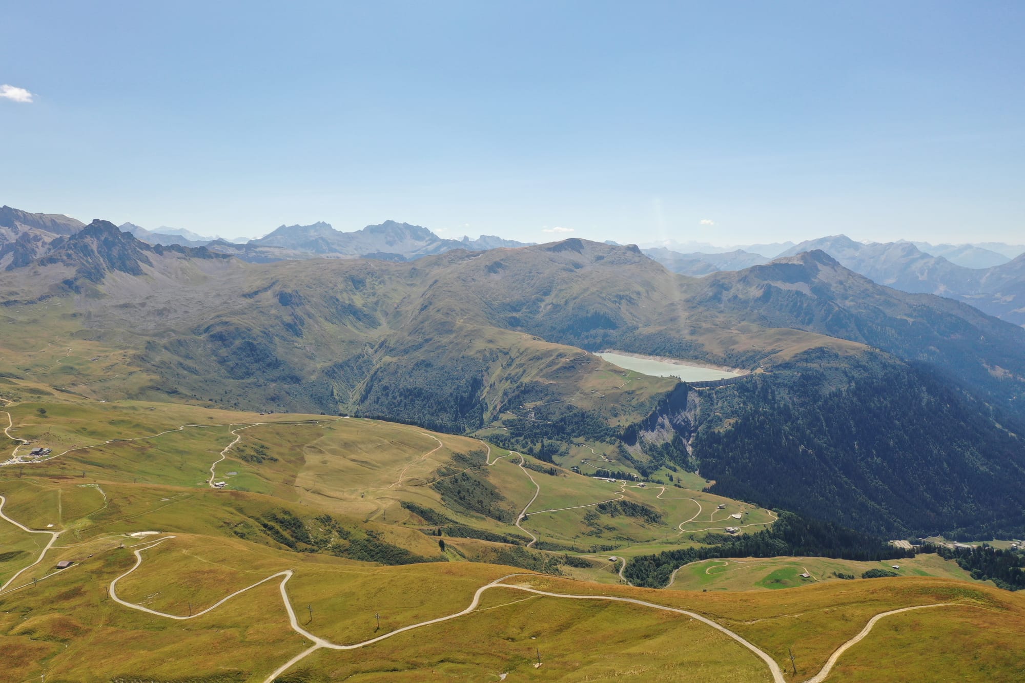
The drone flights from this area captured the landscape in its full scale — winding mountain roads, vast alpine pastures dotted with trails, and the lake visible in the hazy distance.
Valley Explorations: Villages and Drone Flights
Not every day needs to be a summit push. Some of the most rewarding moments came at lower altitudes — discovering villages, flying the drone over unexpected landscapes, and simply absorbing the alpine atmosphere.
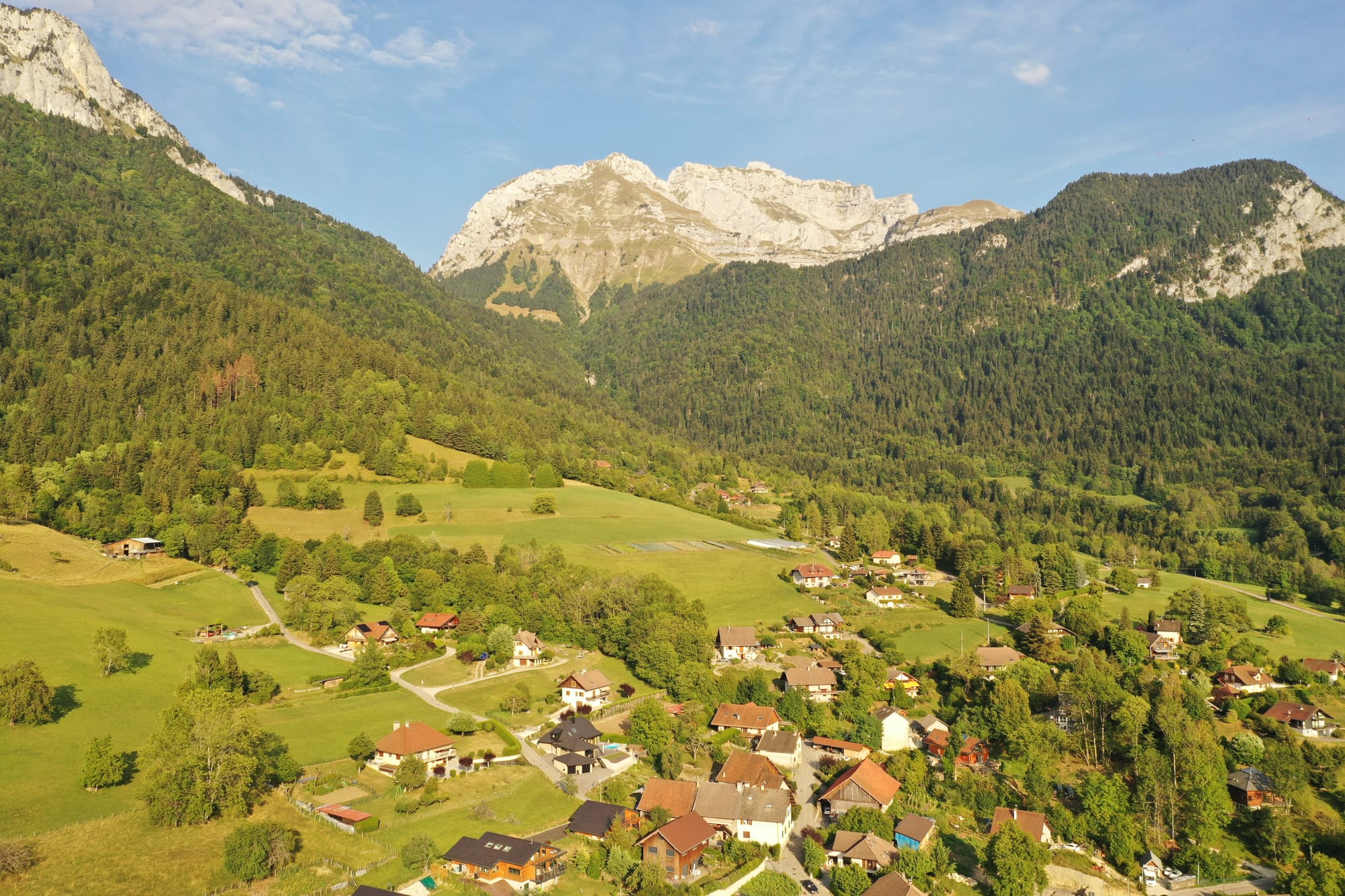
An Alpine Village from Above
One late afternoon, a drone flight over a village nestled at the base of towering limestone cliffs produced an image that looks almost like a painting — red-roofed houses, green meadows, a church, and the massive rock faces of the mountains behind. The golden evening light gave the whole scene a warmth that ground-level photography simply can't capture.
Tips for Hiking with Kids in the French Alps
Having hiked with children aged 9 and 13 across multiple days in the Alps, here are some practical takeaways:
Start early. The mountains heat up quickly in August. Setting off by 9 am means you're at altitude before the midday sun becomes uncomfortable, and you're back in the valley for a late lunch.
Pack more water than you think. There are few water sources above the treeline. We carried two litres per person on longer hikes, and it was barely enough on hot days.
Let the views do the motivating. Rather than promising rewards at the end, point out features along the way — "See that lake? We'll be there in twenty minutes." Small, visible goals keep kids moving.
Invest in proper shoes. The trails around Saint-Gervais and Megève have rocky sections where sandals or trainers would be miserable. Ankle-supporting hiking shoes made a real difference for the younger one.
Bring the drone. This isn't strictly a family hiking tip, but the aerial footage added an entirely new dimension to the trip. The children were fascinated by seeing their hiking routes from above, and the images are among our best. If you don't have a drone, consider booking a scenic flight or helicopter tour to capture similar aerial perspectives of the landscape.
Find the Best Place to Stay
Practical Information
How to Get There
Saint-Gervais-les-Bains is roughly 25 minutes west of Chamonix by car. Megève is another 20 minutes south. Both are accessible via the A40 motorway from Geneva (about 1h30). The hiking trailheads are typically reached by short drives up mountain roads from the main valley. Book a rental car to access remote trailheads and move between hiking areas.
Saint-Gervais and Megève sit in the Mont-Blanc valley, an hour from Geneva airport (GVA) — the most flight-friendly entry to the French Alps for international visitors. GVA has direct flights from most European capitals and several US cities; alternatively, Lyon (LYS) is 2.5 hours away and often cheaper from southern Europe.
Best Trails for Families
The Saint-Gervais highland trails (starting from cable car stations or mountain road parking areas) offer moderate hikes with altitude gains of 300-600 metres. The Megève ridgelines are slightly more demanding but well-marked. Allow 4-6 hours for a full day hike including breaks.
Budget
Parking at trailheads is typically free or €3-5. If you use cable cars to gain altitude, expect €15-25 per adult per ride. Saint-Gervais and Megève have a range of accommodation from mountain gîtes (€60-90/night) to luxury chalets. Pack picnic supplies from valley supermarkets — eating at altitude refuges is expensive (€12-18 for a simple meal).
More Family Adventures
If you're planning more hikes with children, these mountain destinations deliver: — skiing with kids in the Pyrenees — hiking volcanic peaks in Auvergne
FAQ
Q: Are the hikes around Saint-Gervais suitable for young children? A: Most trails are suitable for children aged 7+ with some hiking experience. The paths are well-marked and generally not technical, though some sections are steep. Younger children may need encouragement on the longer descents.
Q: Do you need special equipment for hiking in the French Alps? A: Proper hiking shoes with ankle support, sun protection (hat, sunscreen, sunglasses), and waterproof layers are essential. Trekking poles are helpful on descents. No technical gear is needed for the trails described in this article.
Q: Can you fly a drone in the French Alps? A: Drone regulations in France require registration and adherence to local rules. Many areas in the Alps allow recreational drone flights below 120 metres, but national parks and certain protected zones may have restrictions. Always check local regulations before flying.
Q: What's the altitude sickness risk for children? A: At the altitudes described here (1,500-2,400m), altitude sickness is uncommon but possible. Symptoms include headache, nausea, and fatigue. Ascending gradually and staying hydrated helps. If symptoms appear, descending even a few hundred metres usually resolves them quickly.